 AreaMap
How to measure the acreage of your land
There are four ways to find out how many acres your land is. Which one to use depends on whether the boundary is already on paper and how exact you need to be.
1. Check your deed, plat or county records
If you own the land, its official size is usually on paper already:
- Deed or closing papers. Most list the acreage, and many include a legal description with the length and bearing of every boundary line.
- Plat or survey. If the lot was ever surveyed or subdivided, the plat map shows each line and the total area.
- County GIS or assessor. Most US counties have a free online parcel map. Search your address to see the parcel outline and the acreage used for property tax.
Tax records are a good first check, but they’re often rounded or out of date. They also only cover whole parcels, not the pasture, yard or food plot inside one.
2. Trace it on a satellite map
This is the fastest way to measure any piece of land, including parts of a parcel and land you don’t own yet. In AreaMap:
- Search the address or place, or start where you’re standing.
- Tap each corner of the field, yard or lot on the satellite map. The shape closes on its own.
- Drag any corner to fine-tune it. The acreage, perimeter and every side length update as you move.
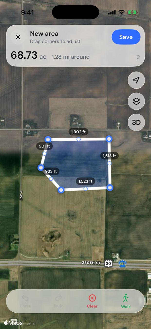
Placed carefully on clear imagery, corners are usually accurate to within a few feet, and AreaMap calculates the area on the curved Earth rather than a flat map, so big fields come out right too. You can switch between acres and hectares, save the shape and export it to Google Earth or a PDF.
3. Walk the boundary with GPS
When trees hide the line on the satellite view, walk it instead. Start AreaMap’s walk mode at a corner and walk the edge; your phone records the path, even with the screen locked, and gives the acreage when you’re back at the start.
Phone GPS is typically accurate to a few meters under open sky and less under heavy tree cover or near tall buildings. Walk at a steady pace and drag any corner that wandered afterwards.
4. Measure with a tape and do the math
For small, simple lots you can measure the sides and calculate:
- Rectangle: length × width.
- Triangle: ½ × base × height.
- Irregular shape: split it into rectangles and triangles and add them up.
That gives square feet. Divide by 43,560 to get acres, or use the acreage calculator. A 100 × 200 ft lot, for example, is 20,000 ft², or 0.46 acres.
This gets slow and error-prone on anything bigger than a backyard, on slopes, or where the sides aren’t square.
When you need a licensed survey
Satellite maps, GPS and tape measures are great for planning, quotes and material estimates. For anything legal (buying or selling land, settling a boundary dispute, building near a property line or getting a permit that asks for one) hire a licensed land surveyor.
Questions
How do I find out how many acres my property is?
Check your deed, plat or your county’s online parcel map first. To measure it yourself, trace the boundary on a satellite map in an app like AreaMap, which gives the acreage instantly.
Can I measure acreage on Google Maps?
Roughly. On a computer, right-click the map, choose Measure distance and click around the boundary back to the start, and Google Maps shows the area. It can’t save or adjust the shape, walk a boundary or estimate materials. A land measuring app like AreaMap does all of that, in acres or hectares.
How accurate is measuring land on a satellite map?
Usually within a few feet when the imagery is clear and you zoom in to place each corner. It’s accurate enough for planning and estimating, but it isn’t a legal survey.
How many square feet are in an acre?
An acre is 43,560 square feet, about 209 × 209 ft as a square.